You will go out in joy and be led forth in peace; the mountains and the hills will burst forth into songs of joy before you, and all the trees of the field will clap their hands. Isaiah 55:12 (photo above - on Mt. Cheam looking south)

Friday, August 17, 2012

The Best Until Last -- Mt. Cheam

Well, we certainly saved the best until last this year. A year ago, Ruth suggested we hike Mt. Cheam, but several reports indicated that many parts of the trail at the end of August that year were still buried under snow. We didn't feel up to dealing with huge snowfields, so we agreed that we would put Cheam on our list of "must do's" and tackle it if the trails were clear in August 2012.

The "Good" Part of the Road
Although it would be challenging, we both felt we could handle the hike; however, we were keenly aware that we would first have to conquer the decommissioned logging road that led to the trailhead. While the Subaru's manual cautioned the owner that it was "first and foremost a passenger car," we had heard of others who had made it to the top in a Forester like mine. I spent the night before the hike watching YouTube videos of off-road adventures, psyching myself up for the drive the next day. Don loaded a shovel and some solid boards that came from an old bed frame into my car, then gave some last minute advice, and I was on my way.

The air was electric with anticipation when Ruth and I met at the school parking lot at 7:30 in the morning on August 16. This was what we had been looking forward to for a whole year. With a set of directions in Ruth's hand and my hands on the steering wheel, we set out on our adventure.

Using Boards to Get Across Deep Water Bar
The drive was smooth as we sailed along Hwy. 1, and still smooth as we wound our way along Chilliwack Road. We turned off at Foley Creek Forestry Service Road and eventually west onto the Chipmunk Creek FSR. At the end of this rather bumpy road, we started up the old logging road towards the trailhead. The first major ditch across the road made us gasp a little, but I threw the Subaru into first gear, took a deep breath, and slowly inched its nose into the ditch, listening for any sound of scraping on the undercarriage. So this was how an AWD actually works -- wheels grabbing when others are spinning.

It took us a full hour to navigate the 10 km. of this bump-and-grind road, and fortunately we had to stop only once to use the boards to negotiate one particularly deep ditch. Finally we were on the short, rocky stretch of road that took us into the parking lot where four vehicles told us we were not alone that day. That was actually quite comforting.

Lady Peak from End of Road
As we unloaded our gear, we met two older gentlemen who had arrived just minutes before us. "Jim," came over to chat, and we asked him if he had hiked the trail before.  His answer? "Yes, about once a year for the past 30 years." Good. We had found someone who could point us in the right direction should we need it. He and his pal, Bob, were planning to hike Lady Peak, the massive neighbour of Cheam.

View to the South
Had the two men not been such photo and video enthusiasts, they would have quickly been miles ahead of us. As it was, for the first hour or so, we caught glimpses of them ahead on the same trail, usually with a camera pointed at something that had caught their eyes.

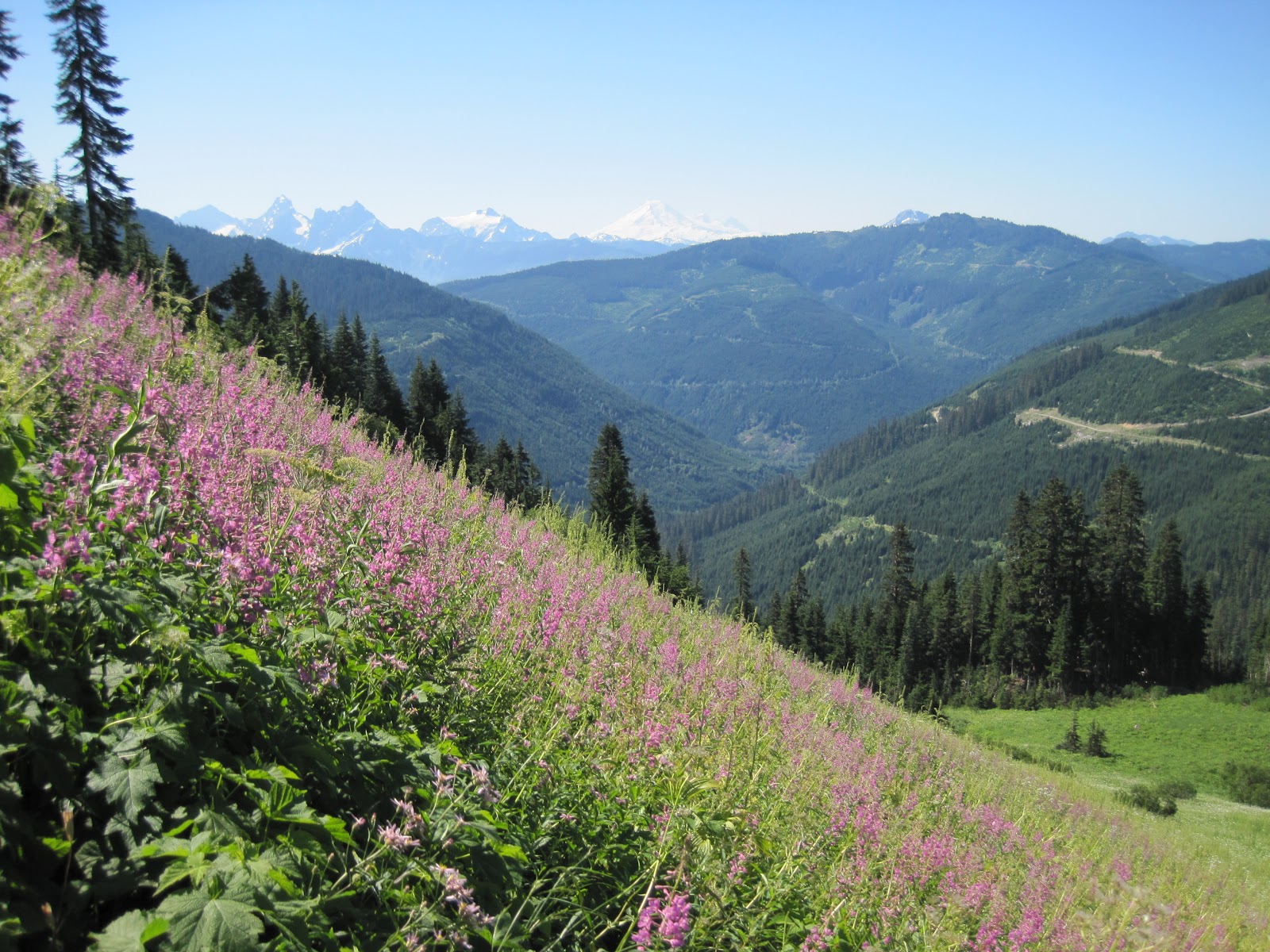
The alpine flowers were in glorious splendour that day. Some we knew well -- Indian paintbrush, mountain lupine, yellow glacier lily, Sitka columbine, alpine heather, spreading phlox, pearly everlasting, cow-parsnip, fireweed and sub-alpine daisies.  Others required an identification search in a field guide when I got home -- Martindale's lomatium, pink monkey-flower, Davidson's penstemon, and heart-leafed arnica. Our eyes feasted on the mountainsides dressed in colour--slopes clothed in subtle shades of blue and purple punctuated with brilliant splashes of pink, yellow and red.

Pink Monkey-Flower
Mountain Lupie, Sub-Alpine Daisy, and Heart-Leaved Arnica
Hillside of Fireweed
Yellow Glacier Lily
It seemed that we gasped with every turn along the trail; the scenery was beyond description. Certainly our surroundings this day were declaring the Glory of God with a resounding shout. In fact, Ruth saw it as a metaphor for 2 Corinthians 3:18.  In every turn, and every new vista, there was increasing glory.

Snow Cave in Middle of August

As we crossed through a mossy bowl then up the other other side, we stepped around a corner and saw one of the snow caves we had read about. It was smaller than it would have been a month earlier; still, it was hard to imagine that this remnant represented only a tiny bit of the snow that filled this area just months before.


Precipitous Back Side of Lady Peak

The back side of Mt. Cheam looks radically different from the side one views from the Trans-Canada, and as we entered the col between two colossal mountains where the trail forked, we wondered which was the one we were aiming for. We followed a less-troddened trail up a slight slope until we could go not a foot farther without falling to the valley 4,000 feet below where Jones Lake lay like an giant sapphire amidst a sea of green. To the right, we looked up, and up, and up. Surely that was not our destination, but we couldn't be sure. We snapped a few pictures and backed away from the precipice.

Ruth Crossing a Snowfield
Sound travels a long way in the thinning atmosphere, and when Ruth caught sight of Jim and Bob starting their ascent of Lady Peak, she called to them to ask which way to go.  Bob pointed to the rocky trail on the other side of the col, so we traversed the two snowfields separating us from the track that wound its way upward.

We were surrounded on every side with breath-taking beauty and stopped occasionally to fill our lungs with the incredibly sweet alpine air.  There were moments when we felt we were on the set of the classic Heidi movie.  As we moved upwards, the trail narrowed and became rockier. Eventually we came to some scree slopes where at every step we knew one misstep would be the start of a tumble that would not have a pretty ending--and perhaps a deadly one.

Trail Up Out of the Col -- The Way to Cheam's Summit
We were not the only ones on the trail, but in the whole day we counted perhaps eleven other happy wanderers--some we caught only a glimpse of on a far-off slope. In an area with a population of four million, it was hard to believe that fewer than a dozen were roaming the same hillsides. We stopped a couple of times to nibble on trail mix and take a draught of the water we carried with us, needing both the instant energy that comes from nuts and dried fruit and the hydration that comes from Adam's ale.

Nutrition and Hydration Break
Gradually, though, we worked our way, step by step, towards the peak that beckoned us with its siren call. Our backpacks grew heavier as our legs led us onward, but nearly four hours after we arrived at the parking lot, we were tramping the last few metres towards that summit we had seen so often as we drove down the highway.

Last Steps Towards the Summit
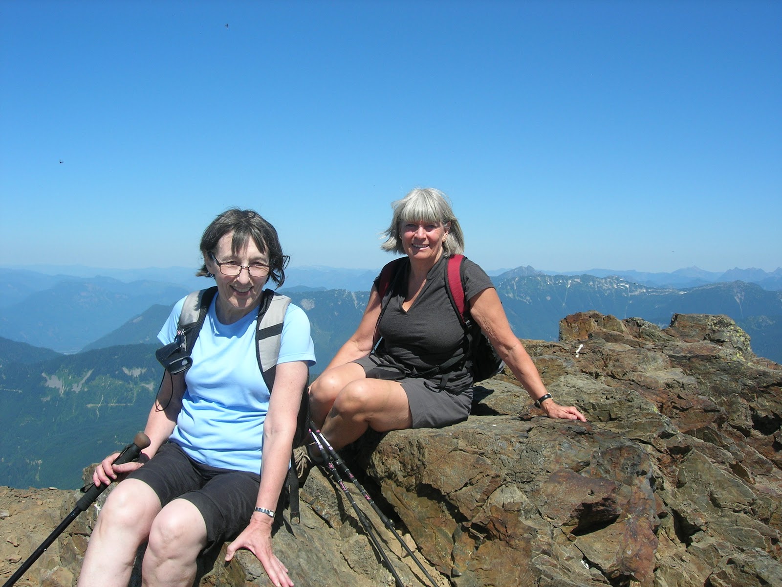
The elevation of Mt. Cheam is 6,929 feet above sea level, and we were at the apex of this mighty mountain. Although that last scramble was in a way terrifying (like, what would happen if a gust of wind came along), neither of us could bear to turn back without taking the iconic picture of us on the top. Fortunately, Jim and Bob had given up their attempt to find a way up Lady Peak and had opted for Cheam instead. They had arrived at the top shortly before us, and Jim offered to take a picture of the two of us taking the last steps of our ascent and then one memorable picture at the top. Neither of us had an appetite for lunch on that stomach-dropping pinnacle, so we made our way down and ate our lunch at a safer spot, but still one with an incredible view.

Sitting at the Top -- 6,929 Feet Above Sea Level
View from Our Lunch Spot
At last, it was time to begin our descent. After most of the day slogging upward, we wondered how our knees would handle going down. We were pleasantly surprised, though, and we made good headway towards the bottom. It was a hot day, and when we reached one of the larger snowfields, we tossed our backpacks aside and threw ourselves onto the ground for a quick roll in the snow.

Linda (top) and Ruth (bottom) Make a Snow Angel or Two


An Exhilarating Splash Before Hitting the Road
Six and a half hours after lacing up our hiking boots, we arrived back at the parking lot--my Subaru sitting alone in the deepening shadows. A quick trip to a waterfall to splash icy water on parched faces, and we were on our way, resting in the thrill of meeting a goal we had set a year earlier.


Tuesday, August 14, 2012

Ramble #5


Ramble #5 is now set. If you are planning to come, please let me know. Here are the details:
  • Hike will be on Thursday, August 16
  • We'll be hiking Mt. Cheam near Chilliwack
  • We're meeting at the school at 7:30, as it is quite a long drive
  • Hiking shoes or boots would probably be a good idea, as the hike is quite rugged in parts and has an elevation gain of close to 700 m.
Here is a description of the hike:http://www.vancouvertrails.com/trails/mount-cheam/

Monday, August 13, 2012

Norvan Falls -- August 10, 2012

Entrance to Lynn Headwaters Park
It didn't look like much of a challenge, but to avoid the Abbotsford Air Show traffic, Ruth and I decided to hike the Norvan Falls trail in Lynn Headwaters Park.  The elevation gain was minimal -- one source quoted 275 m. -- but the distance was longer than some of our earlier hikes.  We figured that by keeping the upward slogging to a minimum, we would get a good idea of how our legs would respond to a 14 km. ramble.

Ruth on One of the First Bridges
We began our venture ambling alongside Lynn Creek, then at the 2 km. point we came to the junction of a short trail that climbed steadily to join up with Headwaters Trail. This section of the trail meandered through sweet-scented groves of red cedar, western hemlock, Douglas fir, and Sitka spruce--a second-growth forest, but impressive nonetheless. Throughout the woods, a new generation of trees has sprouted atop the gargantuan stumps of ancient giants--an object lesson in regeneration. One cannot help but wonder what it would have been like to hike through this grove before the corduroy roads were set down and lumberjacks sawed mercilessly through the giant trunks.

Inside the Cavity of a Massive Tree Stump
While joggers, mothers pushing baby strollers, and dogs were in abundance on the creekside portion of our hike, here we found peace and silence, only the odd person venturing beyond the 4 km. mark. The trail was remarkably well kept, and although it was quite rocky in places, we found the travelling relatively easy. Soon we could hear the rushing water of Norvan Creek, and knew were close to our destination--and our lunch.
Norvan Falls
We scrambled down the creek bank and across the large boulders that in high water would have been submerged under a roaring creek, and perched in the middle of the creek bed. It was the perfect spot for an ideal view of the falls. It was also a reminder that a hike doesn't have to push us to the edge of our physical abilities to be worthwhile. We sat for 30 minutes, nibbling our lunches and simply enjoying the beauty of the spot.

On the return journey, at the 3 km. point, the trail opened up into what is known as the Third Debris Chute, giving Ruth a chance to scan the horizon and try to identify the various peaks -- Crown, Goat, Fromme and Grouse mountains. Here we needed to make a decision whether to continue along the high road (Headwaters Trail) or take the fork for the low road. We opted to take the low road, Cedars Mill Trail, which runs parallel to the creek.
Ruth Identifying the Various Mountain Peaks

We were glad we made the decision, as assorted remnants from the logging days were scattered along the way--rusty wheels, an old logging cart with trees growing out from between the wheels, a bucket hanging from a tree branch, and other relics from when the Cedars Mill operated on this mountainside. It was somewhat sobering to think that here we were, looking at the tools and equipment used by men nearly a hundred years ago. It would never have occurred to them that generations through time would stand in wonder at stuff they had left behind.

Pool at the Bottom of Norvan Falls
Bubbling Water of Norvan Creek

Sunday, August 12, 2012

Ramble #5

I just realized that I didn't post information about Ramble #4 on this blog. Those who asked to be on my e-mail list got the information, but to others who may have been relying on the blog for updates, I'm sorry.

Ruth and I were the only ones who managed Ramble #4 and we went to Norvan Falls in North Vancouver. We want to do at least one more ramble this coming week, so watch for updates and e-mail me if you're interested.

Saturday, August 11, 2012

John Dean Park -- A Ramble into the Past

Water Lilies
This wasn't a ramble for the Regent Ramblers, but since I put the blog together, I figured I could include it if I wanted.  If anyone is looking for a hike near Sidney, I can recommend John Dean Park. There are several trails one can follow, and anyone who loves old-growth forests will enjoy this one, as the park has some of the largest Douglas fir trees remaining on the south coast of Vancouver Island.

Jeanette at Dam that Makes the Emerald Pool
My aunt and I wanted to have a girls day out, but we were only interested in a shopping day if her granddaughter, Hanna, was available. We had a day like that two summers ago, and Hanna had entertained us for hours as we watched her look for bargains to fit her budget. The chances of Hanna joining us were slim, so I suggested a hike and Jeanette was certainly game. She peeked at the Ramblers site and said she wished she could have been here with us. Jeanette, along with my Uncle Don
Snack and Rest at Pickles' Bluff
and their two children, hiked the West Coast Trail close to forty years ago -- long before it was upgraded and became popular. I still remember visiting them shortly after their trip and being enthralled at their slides. Jeanette is older than I am (Uncle Don is 70, and I think she's a couple of years younger), but she can still put in a solid day of hiking--guess that's what comes from a lifetime of being active.

Trees Grow a Lot in 60 Years!
I got up early and headed to Tsawwassen to be sure the 8:00 a.m. ferry didn't leave without me. Jeanette met me at the other end. She had dutifully pulled a trail map off the provincial parks web site, and Uncle Don had given her clear directions of how to get to John Dean Park from the ferry docks, so we were off without hesitation. There was an added intrigue for us in choosing this park, as Jeanette remembered camping there as a child. Little was the same as it had been back then--trees grow a lot in sixty years, and other things decay and disappear. As we walked, we felt like we were stepping back into history and that the ghosts of bygone days were whispering to us along the way.

View from Lookout
The park is situated on top of Mt. Newton. You would have seen this mountain if you have ever travelled to Victoria, as it is the highest point on the Saanich Peninsula. The First Nations people call the mountain Lau Wel New (which means Place of Refuge), and according to the legends of their culture, this mountain enabled their Saanich ancestors to survive the Great Flood. It was here, on the top of Lau Wel New, that the ancient people were able to anchor their canoe with a giant cedar rope until the flood waters subsided. Lau Wel New was the first land available after the Flood. I will add this new piece of information to my collection of Flood legends and share it with my next crop of grade sevens.


Indian Pipe -- aka "Corpse Plant"
Yellow Slime Mould -- aka "Dog's Vomit"
There was much to see as we traipsed merrily along, and we chatted about everything and anything. Jeanette compared the conversation of women to a spider's web--moving out from a topic when something else catches their interest, but always going back to the centre of the web. And there was much to catch our interest. The first time I had seen Indian Pipe was last year when the Ramblers did the Jug Island hike. I was disappointed this year when I didn't see any along that trail, but that disappointment was quickly forgotten when we found the ghostly-white plant in abundance. This wasn't the only oddity along the path. In a place of green and brown, a patch of brilliant yellow cannot help but be noticed. Often confused with Witch's Butter, which is a jelly-like fungi, this organism is simply called Yellow Slime Mould (or sometimes Dog's Vomit). This organism baffles scientist, as it produces spores like a fungus, but is capable of locomotion like an animal--when faced with food shortage, the slime moulds congregate and move as a single body.

Emerald Pool
John Dean was an early pioneer in the area, and he settled on Mt. Newton, building a cabin he called Illahie. He donated his property in 1921, and it became the first donated provincial park in British Columbia. Others followed suit, donating adjoining property, and the park grew to 455 acres. The trail names are all connected to a piece of the past. As we hiked, we watched for anything that Jeanette might recognize from her early years, but for the first hour we saw nothing. Then we came upon a spot labelled "Gazebo Site." Jeanette remembered the gazebo immediately, and memories started to flood back. Next we found the site of John Dean's cabin, then the old campground site, then a rickety bridge crossing a dried-up stream. It was a haunting feeling to know that the silent surroundings were once filled with the laughter of families camping there.

Eerie Silence of the Lily Pond
Looking at the trail map, we headed to the "Emerald Pool," expecting to find a jewel in the woods. It was a tiny, black pool, but somehow it fitted the enigma of the day. When we came to the "Lily Pond," I couldn't help but feel I had slipped into another dimension somehow. It seemed as if an ethereal mist was rising from the milky water, and the silence was deafening. We sat there for quite some time, simply soaking in the mystery.

Four hours after we laced on our hiking shoes, we came to the trail that would take us out of our trip to the past and into the reality of the day. Sandals back on, a quick trip into Sydney for a bite to eat, and it was back to the ferry docks for the voyage home. I must say, that a ramble like we had beats sitting around or fighting crowds of shoppers!

Thursday, July 26, 2012

Jug Island Beach 2012

There were six Ramblers today--Ingrid, Linda, Ruth, Cheryl, Leah, and a very pregnant Angie. It was exactly a year ago today that we first did the Jug Island Beach hike, but today was much brighter and we weren't shooed away by a film crew. It was also a reminder of why Lana decided to replace the Gr.6 Sasamat Lake hike with this one. The trail goes through some incredibly rich rainforest, and while not overly challenging, it is not a walk in the park, either.

Today we failed to see the Indian Pipe we had discovered last year, but the huckleberries were abundant. Angie had quite the feed along the way, and we teased her that the baby she was carrying would probably love huckleberries and hiking. From the "wailing wall," to the pristine beach at the end, the beauty that surrounded us nourished the soul. We all agreed that it was a hike worth doing, even if one had trod the path before. 
Although the beach was not deserted when we arrived, we were still able to enjoy the time we spent sitting on logs snacking on our lunches. You would think we would have been disappointed that we weren't alone, but we actually got a kick out of watching kids skipping stones on the water. We were also entertained by a Labrador retriever who was swimming tirelessly after a stick being thrown over and over by a young couple who had settled in on the one end of the beach.

None of us ventured into the water today, but it wasn't because it didn't look inviting. Had there been another landing spot besides the one that the kayakers had taken over, and had there been a chance to sneak off into the woods to slip into a bathing suit, you just might have seen at least one Rambler splash across to Jug Island. That will have to wait until next year, I guess.

We completed our adventure with a relaxing time in Cheryl's backyard, sipping ice cold water and nibbling on strawberries, grapes, and muffin tops.


We chatted for an hour as only women can--a cross-generational group enjoying our time together. All in all, it was a wonderful day for the Regent Ramblers.

Saturday, July 21, 2012

Ramble #3 -- Thursday, July 26

This hike was such a hit last summer, that Lana added it to the grade six field experiences.  If you haven't been to Jug Island Beach, you've missed one of most idyllic spots in the Lower Mainland.

The Ramblers have decided to do the Jug Island Beach hike again this year, and have set this coming Thursday, July 26 as the date to hit the trail.  Interestingly, last year's ramble to this beach was also on July 26.  We're meeting in the school parking lot at 9:30 a.m. to head out--so pack a lunch and meet us there if you'd like to car pool. If you live in the area, just let us know that you will meet us in the parking lot of Belcarra Regional Park.  Cheryl has invited us to her place for coffee after our hike.

If you intend to ramble with us on this outing, please let me know.

Tuesday, July 17, 2012

Rolley Lake & Falls Hike/walk

Four of us crossed the Golden Ears Bridge for our 55 minute drive to Rolley Lake [Ruth, Leah, Ingrid and Colleen].  Although the day was already warm, we were sheltered by tall trees and shrubbery on our walk around the western edge of the lake.

When we arrived at a fork in the road, Leah directed us to the left (according to the printed instructions) for our 40 minute hike to the falls.  The gradient was steep in places and we "hopped up & over" many large fallen tree trunks.

Down in the valley we crossed  Rolley Creek and then began the incline back up to the waterfalls.  Two viewing points allowed us to gaze over the larger of the two waterfalls, and a bridge gave us time to rest while admiring the wider, lower falls.

 Returning to the fork in the way we headed back along the eastern border of the lake to the picnic and beach area.  Two hours after beginning our adventure, we returned to a cool car that was still sheltered from the sun by gigantic trees in the parking lot.
An active and social morning enjoyed by all.


Monday, July 16, 2012

Ramble #2

Ramble #2 - Rolley Lake - July 17, 2012

Rolley Lake - http://www.vancouvertrails.com/trails/rolley-lake/ - quoted as a 2 hour walk, easy and 5 km long [near Stave Lake ]
Meet at the school at 8:30am and then carpool up to Ingrid's house and we'll leave from there over the Golden Ears Bridge and then on for our walk.  Should be back for a later lunch! 

Saturday, July 14, 2012

Elk Mountain -- 2012 Ramble #1

As we left the parking lot of the school, we still had not decided upon our destination. We both knew that this was the first hike of the season and that our leg muscles needed work, but we also didn't want a "walk in the park." Ruth and I had spent days e-mailing back and forth possible hikes, but it was harder than we imagined to find one that was exciting yet doable. All we knew was that we didn't want to fight the traffic to West Vancouver, and Squamish was too far, so we headed eastward towards Chilliwack.

As Abbotsford faded away into the rear-view mirror, we knew we had to make a decision. The hike on the top of our list, but also one that we felt might be too much of a stretch with its 800 metre elevation gain, was Elk Mountain. Finally deciding that we "could always turn back part way up," we followed the highway to Prest Road and headed southward. As we drove along the devious road that wound its way up the mountainside south of Chilliwack, we were captivated by the number of homes hidden in the woods. Driving along the Trans-Canada, one would never guess that the forested glades above the valley floor harbour so many charming properties.

We finally pulled into the parking area at the trail head. A red pick-up wheeled in moments later, and a fit and energetic gentleman jumped out with his backpack and what looked like a tarp. It turned out that he and the driver of the truck had hiked up earlier in the morning, then glided down into the valley on their hang-gliders. We asked him how long it was to the top, and his response stuck with us all day--and is likely to be a mantra for us on future hikes. "Why does it matter how long it will take? Just keep going until you reach the top--it's the journey that counts."

It didn't take us long to meet the first steep inclines, but we trudged along happily and our legs came through for us.  It was a well-marked trail that had obviously seen many a hiking boot. We eventually came to an old logging road that cut across the trail. With energy waning a little, we stopped for a drink and handful of trail mix. We could see a peak looming to our right and we wondered if that was our ultimate destination--it seemed awfully high.

At the 3.5 km. mark, we came to the rock outcropping that we had seen in pictures. From this spot, we looked over the valley--the Fraser River winding along, a patchwork of little farms, Chilliwack, the Trans-Canada snaking through the middle. Behind the valley, rose the peaks that surround Harrison Lake, and those of what was probably eastern Garibaldi Park. It was an awe-inspiring view, but unfortunately it was partially obscured by the haze of smoke from forest fires in Siberia.

Here we met a couple of other hikers who assured us that it was worthwhile continuing up to the summit. The next 500 metres to the summit was even steeper than what we had already climbed, and to add to the challenge, the narrow trail along the ridge was covered with loose scree.

As we neared the top, the woods opened up into alpine meadows, and what glorious meadows they were--lupines, lilies, columbines, spreading phlox, yarrow, mountain ash--all in full bloom. There is little more wondrous than alpine meadows at the height of blossom. It was like a scene from Heidi, except as Ruth pointed out, if this had been Switzerland, there would have been little villages dotting the mountainside and likely a tram somewhere to take us down.

We knew we were almost at the top when we saw a brightly-coloured wind sock and tell-tale signs of foot traffic to the right of the trail. Here was obviously the spot where those who drifted down to the valley on hang-gliders threw themselves off the mountain. And to think that they first had to hike up carrying all their gear. Of course, the trail head was halfway up from the valley floor, so they would have soared much farther downwards than what they had hiked upwards.

The views at the top were unparalleled. Cultus Lake lay to the southwest, and to the south down the Chilliwack River valley lay Mount Baker, Tomyhoi Peak, the Border Peaks, Mount Slesse, and Mount Rexford. We decided then and there that no matter how difficult the descent, we would be glad we came. For half an hour, we sat at the top drinking in the surrounding beauty and nourishing our bodies and spirits. Yes, the mountains indeed declare the Glory of God.

Getting to our feet, we were aware the descent that lay before us would be no easy matter. Those scree slopes mentioned earlier? Awful to scramble down! With younger knees perhaps the two of us could have leapt along like mountain goats, but parts of the body begin to creak after decades of use, and each step forward had to be placed strategically and carefully. We couldn't afford a misstep, so we fought a knee-grinding fight against gravity all the way down. Our thigh muscles cried out, and the trail seemed twice as long going down as it had coming up. In fact, when we neared the end, we faced a steep climb, but surprisingly we bounced upwards with relief. Five hours earlier when this uphill was a downhill, the spectre of facing it when our energy was spent was foreboding--not in a million years would we have thought of it in relation to pleasure. The uphill quickly ended, though, and the downward agony returned.


Though neither of us said it aloud, we were both watching for another distance marker, yet secretly neither of us wanted to find one in case we were to discover we had a long way still to go. Finally, however, the 0.5 km. marker came into view. I cheerfully pointed it out to Ruth and quickly converted the distance to "about 500 or so more steps." She smiled ruefully, and replied, "Not when my steps are only four inches long." We had to laugh--it seems all our hikes have at least one laugh line that sticks with us, and that is sure to be one of them.


A few minutes later, we could hear the laughter of several younger hikers who had earlier sprung lithely past us, and we could see a glimpse of something silver through the trees. We had pushed ourselves to do a hike that we thought was beyond us, and although we both suffered stiff muscles the next couple of days, it was a hike we would do again in a minute--that is, after we work on the thigh muscles a bit more.


Remember the peak we were wondering about? The one that seemed "awfully high"? When we got to the old logging road on the way down, I pulled out my binoculars and spotted the hand-gliders' windsock fluttering in the breeze. It was indeed our destination--perhaps it was a good thing we didn't know that on the way up.